File:Traffic on Interstate 405, Los Angeles, California LCCN2013632154.tif

Dimensioni di questa anteprima JPG per questo file TIF: 800 × 534 pixel. Altre risoluzioni: 320 × 214 pixel | 640 × 427 pixel | 1 024 × 683 pixel | 1 280 × 854 pixel | 2 560 × 1 709 pixel | 7 360 × 4 912 pixel.
File originale (7 360 × 4 912 pixel, dimensione del file: 206,9 MB, tipo MIME: image/tiff)
| Questo file e la sua pagina di descrizione (discussione · modifica) si trovano su Wikimedia Commons (?) |
Dettagli
| Descrizione |
English: Title: Traffic on Interstate 405, Los Angeles, California
Physical description: 1 photograph : digital, tiff file, color. Notes: Title, date, and keywords provided by the photographer.; I-405 is a heavily-traveled thoroughfare used by commuters and freight haulers along its entire length and has earned its place as the busiest and most congested freeway in the United States.; Credit line: The Jon B. Lovelace Collection of California Photographs in Carol M. Highsmith's America Project, Library of Congress, Prints and Photographs Division.; Forms part of: Jon B. Lovelace Collection of California Photographs in Carol M. Highsmith's America Project in the Carol M. Highsmith Archive.; Gift; The Capital Group Companies Charitable Foundation in memory of Jon B. Lovelace; 2012; (DLC/PP-2012:063). |
||||||||||||||||||||||||||
| Data | Scattata il 4 luglio 2012, 01:26 (secondo i dati Exif) | ||||||||||||||||||||||||||
| Fonte |
Library of Congress
|
||||||||||||||||||||||||||
| Autore |
|
||||||||||||||||||||||||||
| Licenza (Riusare questo file) |
No known restrictions on publication.
|
||||||||||||||||||||||||||


| Luogo dello scatto | | Posizione di questa e altre immagini su: OpenStreetMap |
|---|
Licenza
| Questa opera proviene dalla collezione Carol M. Highsmith Archive della Biblioteca del Congresso. Secondo la biblioteca, non esiste alcuna restrizione nota del diritto di copia sull'uso di quest'opera. Carol M. Highsmith has stipulated that her photographs are in the public domain. Photographs of sculpture or other works of art may be restricted by the copyright of the artist. |
 |
Cronologia del file
Fare clic su un gruppo data/ora per vedere il file come si presentava nel momento indicato.
| Data/Ora | Miniatura | Dimensioni | Utente | Commento | |
|---|---|---|---|---|---|
| attuale | 02:47, 3 set 2016 | 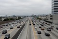 | 7 360 × 4 912 (206,9 MB) | Fæ | LOC 2013632154, Carol M. Highsmith collection. P646.8186 TIFF (206.9mb) |
| 02:46, 3 set 2016 | 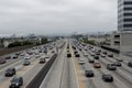 | 7 360 × 4 912 (206,9 MB) | Fæ | LOC 2013632154, Carol M. Highsmith collection. P646.8186 TIFF (206.9mb) |
Voci che usano questa immagine
La seguente pagina usa questo file: